
Human activities have in the past, and still continue to transform the natural landscape. Population growth, over-exploitation of resources, and economic development are some of the causes for this transformation that have resulted in over depletion of natural resources in many parts of the world. Land use management is a key aspect in environment management. It supports to ensure that various parcels of land are put into proper use to ensure that both people and nature thrive.
Defining present and projecting future conditions of the land is an important activity in ensuring that measures are put in place that would see activities carried out in manner that would result in net gain in environmental management.
In order to identify how to incorporate equitable and climate-smart alternatives into land use decisions for conservation, ABCG has been developing methodological approaches for scenario analysis in land use planning, and guidelines for its application in Africa. Scenarios can be possible strategies that achieve land use planning objectives through tools like prioritization. Scenario analysis and planning focuses on developing alternative futures to identify favorable land uses by evaluating scenarios against landscape objectives.
 Gabon rainforest
Here are eight prioritization steps to apply in land use planning. ABCG applied these steps within four African countries: Republic of Congo, Democratic Republic of Congo, Tanzania, and Madagascar to support the incorporation of biodiversity conservation into land use planning. This methodological approach for scenario analysis, and guidelines for its application in Africa, is available in this report: Four African Case Studies Exploring How to Incorporate Biodiversity into Land Use Planning Using Spatial Prioritization and Scenario Analysis
Step 1 – Planning Issues, Drivers and Actors of Land Use Change
This step aims to understand the drivers and actors causing land use change and implications for informing landscape goals, i.e., vision of the future. This sometimes also helps identify what business as usual looks like (i.e., “current trends” scenario) as a baseline for the future to more ideal scenarios. It can also be used to strategically target vulnerable areas for land use change as potential conservation areas. Assessment of trends and likely trajectories of key drivers of landscape change might include direct drivers (e.g., agricultural land use expansion and resource extraction); and indirect drivers (e.g., demographic change, and economic development). Some estimation of how these might affect key conservation values including land cover, at least qualitatively, is useful.
Step 2 – Vision and Planning Goals Identified
It can be useful to start the process with a visioning exercise to identify different stakeholder visions for the landscape and its land uses. For alternative visions, a “storyline” approach can be useful to characterize qualitatively different world-views. From here planning goals can be identified on what the outcome of planning should achieve, then it is easier to start delving deeper into what specific more quantitative objectives can be identified for land use strategies. Goals are very important to identify and typically drive land use planning.
Step 3 – Landscape Characterization
The next step is to gather data to characterize the landscape in the context of current land use and other necessary data that will feed into the remaining steps. Key datasets include the: Current land use system, including the protected area network. Also important, where possible, is understanding the future potential of new or existing land uses. This might include the suitability of the landscape for different crops or areas suitable for extraction of natural resources; identification of key conservation values and their distributions; infrastructure, particularly roads (current distribution, plans); population data and town/village locations; land ownership; current management interventions (including incentives like REDD+).
Step 4 – Potential Land Use Planning Strategies and Their Objectives
Developing land use planning scenarios is most useful when the specific management strategies and their objectives are used as a basis for the analysis. This step requires stakeholders to identify the potential land use strategies that can be used through the next steps of the planning process, and then identifying where these are going to be most useful.
Step 5 – Spatial Prioritization and Scenarios of Land Use Strategies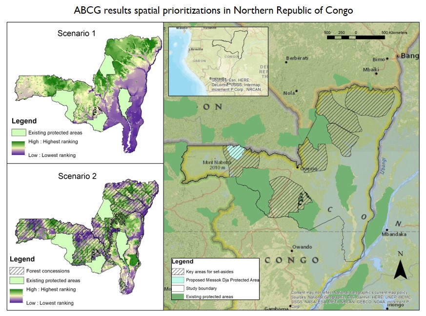
Step 6 – Assess Scenarios with Landscape Performance Metrics
Once scenarios are developed based on the objectives, existing or new metrics can be used to evaluate scenario outcomes (i.e., landscape performance). Ideally metrics are linked to conservation objectives and targets. For example, one metric might measure the extent of change in a conservation feature’s distribution compared to the target. For each scenario the benefits and likely the trade-offs between conflicting objectives can be measured where useful. Scenario outcomes, including maps and associated landscape performance metrics, can be presented to stakeholders typically during a workshop. Preferable and plausible scenarios are chosen from the range of explored scenarios to develop final land use planning recommendations in the final steps.
Step 7 – Summarize Findings
It is important that for any technical analysis that findings are summarized in a way that make it easier for decision-makers and stakeholders to understand and use these recommendations. This means summarizing the key findings around which land use strategies might be best where, what are the trade-offs, how are targets being met.
Step 8 – Make Key Recommendations
Finally, even though the findings might be summarized in step 7, a final set of key recommendations are made that can be presented quickly and easily to decision-makers and stakeholders. Doing this well can help ensure that all the technical work can easily be digested and be more likely to have impacts on the ground.
Download the report here: Four African Case Studies Exploring How to Incorporate Biodiversity into Land Use Planning Using Spatial Prioritization and Scenario Analysis
canadian pharmaceuticals online
best online canadian pharmacy review
drug canada
canadiandrugstore.com
online pharmacies in usa